The
Travelogues of Diane and Dave
|
The
Travelogues of Diane and Dave
|
|||
|
|
 |
|
|
|||||||
|
|
|
||||||
|
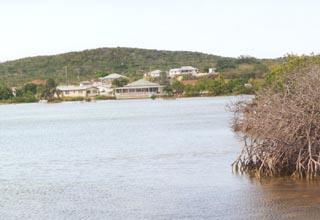
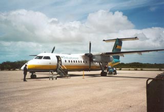
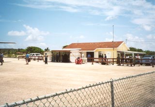
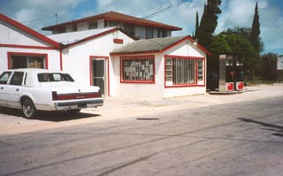
How many times have you daydreamed about relaxing on the powder soft sand beach of your very own private tropical island, with a cool drink in your hand, a soothing Caribbean breeze wafting over your body, while sitting in the shade of a thatched roof gazebo with nary a soul in site. We've discovered how to make that dream come true. Simply rent Little Deadman's Cay, located just ¾ mile off the coast of Long Island, one of the more southern Bahamian islands. (Click here for maps). It all started with our arrival at Deadman's Cay airport on Long Island on Sat afternoon. We were met at the airport by Clarence, the local caretaker. We were told that he would be wearing a red hat. Unfortunately, we discovered that a lot of the locals on Long Island wear red hats! We lucked out on the fourth person we approached and we were soon in his car with our luggage heading for the local grocery store for our provisions. While the store did not have a large selection, it seemed it had a little bit of everything. If you couldn't find something, you just had to ask.
After stocking up we were driven to the public dock where we met Ricky, our water taxi driver to Little Deadman's Cay. Ricky's boat is larger than the one that comes included with the island rental and it kept us and our luggage dry on the short ¾ mile hop over to the island. After a short intro to the house and how to operate it's systems, we were left alone on our own little island paradise for the next 7 days. Our first two days on the island, Sat. and Sun., we pretty much just relaxed around the beach and explored the island. One day for fun we walked around the perimeter. According to my GPS, it was a 0.8 mile walk around the outside of the island. Except for the beach area, the rest of the island perimeter was very rocky. A short stretch was overgrown with mangrove bushes and we had to walk out in the water to get around the impenetrable growth. On Monday we made our first foray out into the local waters. We hired Richard, a local fisherman, to teach us how to fish, Bahamian style. Unfortunately, neither of us had any bait. We spent the first 2 hours or so trying to catch some bait with an artificial lure, to no avail. Richard next tried going ashore on several of the local deserted cays to try and catch a land crab. Finally, after many tries he caught one. This was our first introduction to land crabs. They are huge! We're used to seeing sea crabs like they catch in Chesapeake Bay back home in MD. But this land crab had a body the size of a soft ball and legs about 12 inches long. They also have a large claw (bigger than my hand) for fighting. To catch the crab, Richard had to reach all the way down into the crab's tunnel, putting his whole arm up to his shoulder, down into this hole to grab the crab and pull it out. NO WAY I would stick MY hand down into some hole with a crab at the other end! Unfortunately, the fishing wasn't too good that day. All we caught was a small grunt which Richard lost overboard while cleaning it. Oh well, we had fun trying ! Tuesday dawned a new day and new adventures. Today after a long relaxing morning in bed, we boated up to Blue Hole Cay. The bay necks down to a narrow channel that forms the main channel into and out of Deadman's Salina, the large bay we were located in (click here for maps). Then, from the inlet, it was a short hop over to an old deserted barge. It had run aground years ago in the shallow water while delivering lumber. Now it was a rusting hulk with a large, eagle-sized, nest on one end. From there we checked out some old salt works ruins. A long time ago a salt company had come to the island and subdivided the large salina into many small shallow pools. As the water would evaporate under the hot Bahamian sun, the natural sea salt would be left behind to be harvested. Then one year it was very rainy, diluting the salt water pools and resulting in a much diminished harvest. The salt company abandoned all its facilities and left the island. The ruins we explored looked like an old dock or bridge between two small cays. The water was deep enough to go around behind the cays and we discovered a small shallow bay with deep water pools. We pulled ashore on a sandy beach, enjoyed a picnic lunch and a skinny-dip before we returned back home to our own Little Deadman's Cay. Wednesday we arranged a car rental for the day thru Ellen's Inn. She met us at the public dock on Long Island with a very nice Nissan Sentra. She spent a long time telling us about all the southern Long Island sites we shouldn't miss. She was a wealth of information. After some brief paperwork we were off and on our own. Long Island is about 70 miles long and the one main "highway" that runs its length isn't set up for highway driving so we concentrated on just seeing the southern half of the island. We checked out Chimney Rock, Turtle Cove, Clarencetown (the capitol city of Long Island), and Gordon's Beach. (Click here for maps)
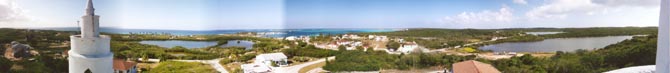
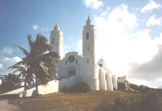
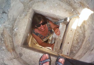
Chimney Rock and Turtle Cove were great examples of the natural beauty of the northern coast of Long Island. Clarencetown was a bustling place down at the main dock. It was Wednesday, noon time and the once a week mail boat was in town. The mail boat is how the island gets all it's supplies, everything from toilet paper to heavy machinery. All the island businesses were in-town with their pickup trucks getting all the supplies they had ordered. We enjoyed watching the hustle and bustle while we ate our lunch at the Harborview Restaurant down by the dock. Another good place to check out in Clarencetown is the Catholic Church. It's up on a hill behind the town. The church lets visitors climb up in one its spires for a great panoramic view of Clarencetown, the harbor and the bay beyond.
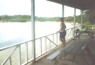
We headed back to the car and drove back north. Along the way we kept stopping off at stores looking for fresh fish. Everyone must have been having bad luck fishing because no one had any fish to sell. We dropped the car off at Ellen's Inn and they in turn dropped us off at the public dock so we could boat back to Little Deadman's Cay. Thursday was another slow relaxing day at home. For lunch we wanted to boat southward down the bay to Kooter's Restaurant. We had seen the place while out driving and it was located right on the water. It took us quite a while to get there since the boat didn't go very fast. When we got there, we found a public dock where we could tie up the boat and then we walked over to the restaurant. Unfortunately, it turned out to be more of a "burger" type place rather than a real restaurant, but fortunately, they also had fish and conch sandwiches which is what we ordered. They told us it would take about 30 minutes. After about an hour and a half, our orders were ready. We were not sure what took so long, but the restaurant had a nice deck overlooking the bay so while waiting, we could amuse ourselves watching all the fish in the water.
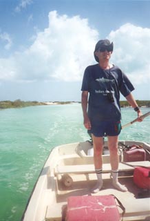
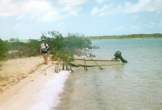
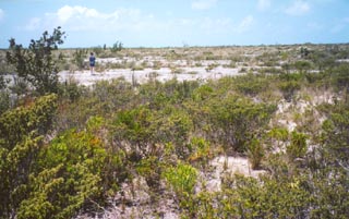
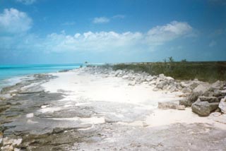
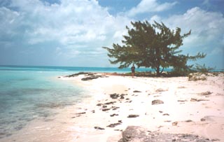
Friday, our last full day in paradise. We were getting a little restless being "cooped" up on the island and were looking for someplace exciting to go to. Looking at our charts, we decided to try and make our way over to the southern beach, about 5 miles away. (Click here for maps) We plotted out a probable course we could take, part by boat and part by hiking. Our starting point was the old salt company ruins where we had picnicked back on Tuesday. From there we thought we should be able to hike about 4 miles along the old salt company dikes to the beach. While we were tying up the boat at our old picnic spot, a high powered fishing boat with 3 bone fishermen onboard, zipped right by us and continued further into the bay in the same direction we were planning to hike! We figured if that larger boat could go that way, certainly we with our smaller, shallower boat could follow them. We piled everything back into the boat and took off after the fishing boat in slow pursuit. We lost sight of the other high speed boat in minutes. However, what we discovered was a long deep water channel that lead way back into the bay. It looked like the old salt company had dredged the channel when they made the dikes. We used my GPS to mark our way along the channel, essentially leaving "electronic bread crumbs" to follow on our way back out. The deep water channel, about 5' deep, lead us for about 4 miles back into the maze of shallow water bays. We used the GPS and the nautical chart we had to determine our exact location along the entire route. Eventually, the deep water channel took a left turn, but we needed to take a right turn. So we turned off the motor, propped it up, and poled our way along. We soon found another deep channel that lead the way we wanted to go and we were able to put the poles away and boat some more. We eventually got as far as we could go by boat. We pulled the boat up on to a sandy beach and securely tied it up to some sturdy mangrove trees (I didn't want the boat to drift off on us while we were gone), packed our day pack and started off on a ¾ mile hike across a narrow strip of land twixt us and our destination beach. After leaving the boat, our fist obstacle was to climb up a low rise. The sight that greeted our eyes at the top was fabulous! We had been afraid that the hike would be thru dense, impenetrable, tangled growth. What we instead found was a wide open, flat, dry, rocky expanse of scrubby growth. We could easily walk thru it. Off in the distance, we could see the shimmering aquamarine water, our final destination. Just on the other side of the low rise, we discovered an old road that again must have been left by the salt company. We headed off across the plain, creating "electronic bread crumbs" on my GPS so that we could find our way back to the boat. The beach was beautiful! There were sections of rockiness separated by stretches of powder soft white sand beach. Once we hit the beach, we hiked another mile north along the coast to a lone solitary Casuarina tree we could see in the distance. There we rested, played in the surf, and had a picnic lunch. We eventually, regretfully, had to turn around and head back. Using the "electronic bread crumbs" on the GPs we easily found our way back to the boat and then thru the deep water channels back to the original salt company ruins. From there it was just a short hop, skip and a jump back home.
[Editor's note: I would NOT attempt this adventure alone without a good chart, compass and GPS. This is definitely NOT an area to get lost in! There are no distinctive landmarks, and when standing up in the boat and looking around it is VERY difficult to discern your way amongst the maze of channels, bays, low dikes, and small cays. Also, you need to watch the water ahead of you for shallow spots and constantly monitor the motor to make sure the prop is not dredging up sand. We also did this during low tide. I figured that way as the tide changed, the water would be getting deeper, not shallower.] We still had some time left over in the day so we decided to try out the local snorkeling. First we snorkeled along the rocky coast of Little Deadman's Cay between the beach and the boat dock. Then we motored over to nearby Jim's Cay where we snorkeled around the small cay twice. Then it was back home to Little Deadman's Cay. We were scheduled to leave the next day and we still needed to repack. Saturday morning we got up early. We figured we'd been here a whole week and we had yet to see the sunrise! We watched and took several photos. It wasn't long and Ricky was there with his boat to take us back to the "mainland". From there it was back to Deadman's Cay airport, then Nassau airport, then Miami airport and eventually Baltimore-Washington International airport and home, congestion, pollution, traffic, work, noise, . . . . Ahhh, if only vacations could last longer. Back in 1623, John Donne wrote that "no man is an island". But as we recently discovered, who cares, when you can rent your very own private tropical Caribbean island called . . . . Little Deadman's Cay. |
||||||||||||||||||||||||||
|
|
|
Here's the Official Deadman's Cay website. |
|
|
|
last revised
:
April 25, 2020
|
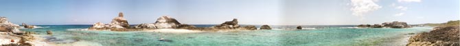
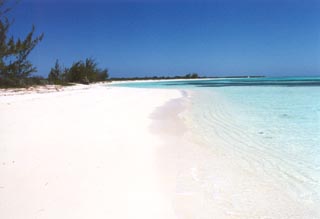 From
Clarencetown, we continued south until the road ended at a gorgeous beach
that extended south as far as our eyes could see. We walked about a mile
south along the beach toward an old ship wreck. We kept walking but the
ship never seemed to get any closer. There were two other sets of footprints
on the sand but they ended and turned back about halfway along our walk.
Then it was just our footprints in the sand. This was one of the finest
sand beaches we'd ever seen.
From
Clarencetown, we continued south until the road ended at a gorgeous beach
that extended south as far as our eyes could see. We walked about a mile
south along the beach toward an old ship wreck. We kept walking but the
ship never seemed to get any closer. There were two other sets of footprints
on the sand but they ended and turned back about halfway along our walk.
Then it was just our footprints in the sand. This was one of the finest
sand beaches we'd ever seen.