|
Unfortunately, 2003 was a bad year for forest fires in Montana. The night
before we were to leave for Montana, we called the Forest Service District
offices in Montana and learned that there were large area closures due
to fires in the Lake Plateau area where we were planning to go. After
several more phone calls that night, the Forest Service rangers recommended
another area in the Beartooths called the East Rosebud Trail (aka: The
Beaten Path) It was a 26 mile long end to end trail that started at the
East Rosebud Lake near Roscoe and traveled up a valley past several lakes
to a high alpine area. Then the trail descended back down another valley
to another trail head near Cooke City. Since it was about 100 miles by
car between the two trail heads and we only had one rental car, we decided
we'd hike in halfway, then turn around and hike back out the way we came
in. Changing our backpack trip last minute that evening, meant that we
had to change some of our motel reservations also. Luckily the time zone
difference between Montana and Maryland worked in our favor and we were
able to do our last minute trip replanning till late in the night.
 The
next day we flew from BWI to Bozeman, arriving around 11pm. The next morning
after a short detour to an outfitting store in Bozeman for a 'Gaz' canister
for our backpacking stove we drove off to the trail head. We stopped off
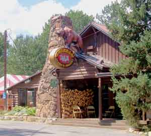
for lunch at the "Grizzly Bar" in Roscoe. The Rangers had told
us it was a great place for steaks and they were right. The
next day we flew from BWI to Bozeman, arriving around 11pm. The next morning
after a short detour to an outfitting store in Bozeman for a 'Gaz' canister
for our backpacking stove we drove off to the trail head. We stopped off
for lunch at the "Grizzly Bar" in Roscoe. The Rangers had told
us it was a great place for steaks and they were right.
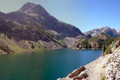
We finally arrived at the trailhead at East Rosebud Lake around 1pm,
a little later than I had hoped, but we still had several hours of good
daylight ahead of us. East Rosebud Lake looked like it was a favorite
destination for fishermen. There were quite a few nice, small cabins dotted
around the shoreline. Several of them were available as vacation rentals.
The beginning of the trail lead us up a narrow valley along side the East
Rosebud Creek thru an area of forest that had been destroyed by a forest
fire back in 1995. The trees were just beginning to grow back. With little
to no trees, we were out in the sun a lot. Fortunately, the upward grade
was very gentle and the air temperature was not too hot.
|
|
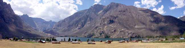
Here we are arriving at East Rosebud Lake. The shoreline is
dotted with small vacation cabins. The trailhead is further ahead
off to the left.
|
|
|
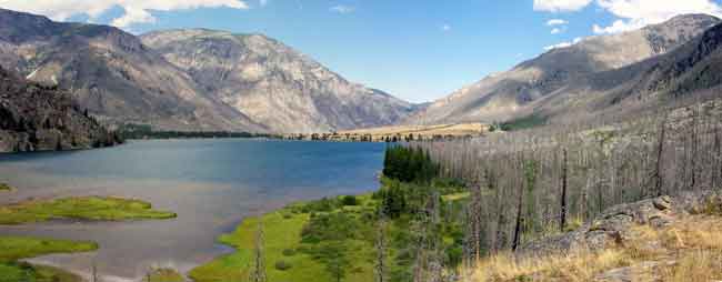
The trail followed the east (right-hand) side of the lake
passing thru a wooded area that had burned back in 1995.
|
After just 3 miles we were at Elk Lake, our first lake. There were quite
a few nice campsites in the woods surrounding the northern end of the
lake.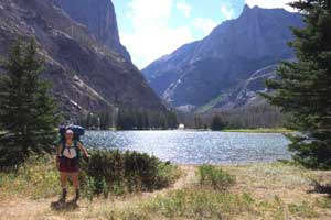 So far the trail had been easy, but about 2 miles beyond Elk Lake the
trail entered a narrow rocky gorge and started a long series of switchbacks
up through an old rock slide. Someone years ago had done a great job at
building the trail. As rocky as the surrounding area was, the trail tread
was nice and clear and the grade was fairly gentle on my heart and lungs.
The notch at the top of the gorge formed a natural dam that created the
second lake in the series, Rimrock Lake. We were now 6 miles from the
trailhead. We followed the trail around the shoreline looking for a suitable
camping site. We had been hoping to make it to the third lake (Rainbow
Lake, one mile father) but our feet were sore and our legs were tired.
Campsites at Rimrock Lake were very limited. There was a group of 4 teens
camped at the best spot near the middle of the lake so we continued on
to the southern end. Just before the trail left the lake and entered the
woods again we found the remains of an old site up on top of a 100 foot
cliff overlooking the lake. On the opposite shore was East Rosebud Creek
cascading down a rocky gorge into the lake.
So far the trail had been easy, but about 2 miles beyond Elk Lake the
trail entered a narrow rocky gorge and started a long series of switchbacks
up through an old rock slide. Someone years ago had done a great job at
building the trail. As rocky as the surrounding area was, the trail tread
was nice and clear and the grade was fairly gentle on my heart and lungs.
The notch at the top of the gorge formed a natural dam that created the
second lake in the series, Rimrock Lake. We were now 6 miles from the
trailhead. We followed the trail around the shoreline looking for a suitable
camping site. We had been hoping to make it to the third lake (Rainbow
Lake, one mile father) but our feet were sore and our legs were tired.
Campsites at Rimrock Lake were very limited. There was a group of 4 teens
camped at the best spot near the middle of the lake so we continued on
to the southern end. Just before the trail left the lake and entered the
woods again we found the remains of an old site up on top of a 100 foot
cliff overlooking the lake. On the opposite shore was East Rosebud Creek
cascading down a rocky gorge into the lake.
|
|
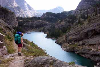
In the shot above, Diane is leading us up the steepest, rockiest
part of the trail just before Rimrock Lake.
|
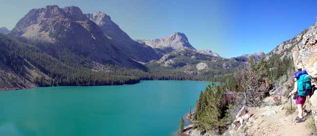
Above: Here we are at Rimrock Lake. You can see the trail
following the right hand shoreline. There's a nice strong wooden
bridge crossing the creek out of sight to the lower right in
the photo.
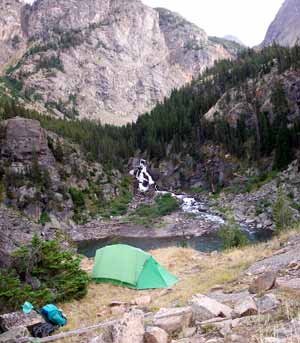
Right: This was our campsite above Rimrock Lake with East Rosebud
Creek cascading down the hillside in the background.
|
 |
The next morning we got an early start and quickly covered the remaining
mile to Rainbow Lake. Rainbow was a much larger lake with loads of campsites
at the southwestern end. If you wanted more privacy you could head east
around the southern end, cross two large feeder streams and find a large
flat peninsula that jutted out into the lake that appeared to offer nice
camping areas. We regretted not having pushed on a little more last night
to make it here for camp, but there was just no way I would have made
that last mile. After a brief stop and snack, we pressed on towards the
fourth lake in the series.
|
|
The trail follows the western shoreline of Rainbow Lake. At
the far end of the lake are many campsites.
|
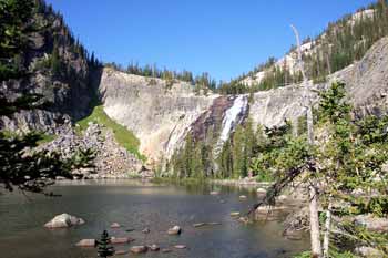
 After
leaving Rainbow Lake it was another 2 miles of uphill switchbacks thru
the woods to lake number 4, Lake at Falls shown to the right. The lake
is named for the two dramatic waterfalls that cascade down from Martin
Lake hidden from view way up in the surrounding mountains to the south
(left side of photo). There were no real suitable places for camping at
the lake. After
leaving Rainbow Lake it was another 2 miles of uphill switchbacks thru
the woods to lake number 4, Lake at Falls shown to the right. The lake
is named for the two dramatic waterfalls that cascade down from Martin
Lake hidden from view way up in the surrounding mountains to the south
(left side of photo). There were no real suitable places for camping at
the lake.
 Continuing
on from Lake at Falls we got a 1 mile respite from climbing. The trail
was a nice easy flat walk past Big Park Lake (lake number 5). It isn't
really very big at all, it's actually more of a large shallow pond surrounded
by woods. Someday it will probably fill in with sediment and become a
grassy meadow. From there we crossed Granite Creek on a nice new timber
bridge and then entered another series of switchbacks up thru the woods.
From Lake at Falls it was 2.8 miles to the sixth lake, Duggan Lake. It
was a small lake with a large dramatic 100 foot waterfall called Impasse
Falls. From the lake it's 0.2 miles of switchbacks up to the tippy top
of the waterfalls for a great view of Duggan Lake below. Continuing
on from Lake at Falls we got a 1 mile respite from climbing. The trail
was a nice easy flat walk past Big Park Lake (lake number 5). It isn't
really very big at all, it's actually more of a large shallow pond surrounded
by woods. Someday it will probably fill in with sediment and become a
grassy meadow. From there we crossed Granite Creek on a nice new timber
bridge and then entered another series of switchbacks up thru the woods.
From Lake at Falls it was 2.8 miles to the sixth lake, Duggan Lake. It
was a small lake with a large dramatic 100 foot waterfall called Impasse
Falls. From the lake it's 0.2 miles of switchbacks up to the tippy top
of the waterfalls for a great view of Duggan Lake below.
From Duggan it was another mile to Twin Outlets Lake. Twin Outlets was
difficult to see in its entirety. It seemed like it was an interconnected
collection of several small ponds. The most important aspect of Twin Outlets
Lake was that it meant that we only had 1.2 more miles of uphill to Dewey
Lake, our destination for the day! Woo-hoo!
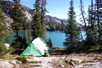 Dewey
Lake was gorgeous. The fact that it meant that we were done for the day
and I could take my heavy pack off made the lake even more gorgeous. It
was a good size, rimmed by tall mountains to the southeast. There was
a large group of fishermen camped along the northeast shore so we proceeded
around to the western shore where we found a plethora of fine campsites
with lake views. We had hiked 8 miles today, all uphill. We quickly set
up our tent and then relaxed with a supper fit for a king and his queen.
We were planning on staying here for the next three nights and going on
day hikes for the next two days before we left to go back down to the
trailhead. Dewey
Lake was gorgeous. The fact that it meant that we were done for the day
and I could take my heavy pack off made the lake even more gorgeous. It
was a good size, rimmed by tall mountains to the southeast. There was
a large group of fishermen camped along the northeast shore so we proceeded
around to the western shore where we found a plethora of fine campsites
with lake views. We had hiked 8 miles today, all uphill. We quickly set
up our tent and then relaxed with a supper fit for a king and his queen.
We were planning on staying here for the next three nights and going on
day hikes for the next two days before we left to go back down to the
trailhead.
|
|
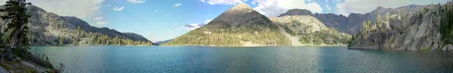
A panoramic shot of Dewey Lake looking northward.
|
|