The
Travelogues of Diane and Dave
|
The
Travelogues of Diane and Dave
|
|||
|
|
Chapter 2: Backpacking in the Beartooth Wilderness, Part 2 |
|
|
|
|
||||||||||||
|
|
||||||||||||
|
|
|
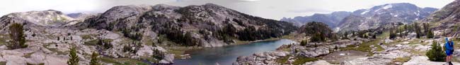
That next day dawned bright and clear. From the creek, we resumed our uphill climb on the main trail. After about 2 miles we crested the top of the plateau and arrived at Fossil Lake, elevation about 10,000 feet. It was huge. It was also very segmented. It was hard to make out a main body of water. It was also very hard to take in the whole lake in one photo. It would probably take forever to walk around the lake following its shoreline into every cove and bay and out and around every finger and peninsula jutting into the water. There were also loads of great secluded campsites all over the place.
We continued along the trail to the western end where the trail started
its slow descent down the next valley on its way to Cooke City. At the
start of the descent
It was warm enough when we got back to take a quick dip in Dewey Lake, and I do mean quick! The water was very cold. Diane managed to get in and out rather quickly. I on the other hand stood in the water up to my shins for some time trying to muster my courage to take the plunge. The sight of Diane getting in and out so "easily" irked me and I just had to "do it". Finally, I threw all caution to the wind and dove in. OHHHH F@%#^$&%*&% !! IT WAS COLD !! My whole life passed before my eyes as I feared the cold shock would stop my beating heart. I couldn't doggie-paddle the 10 feet back to the shore and scramble up on the rocks out of the water fast enough! To this day I still don't believe I did it, and neither does Diane!
Shortly past the waterfall we entered the beginning of a large rocky alpine valley. Off to the right side of the valley was a lovely small lake called Oly Lake. It would have made for a real nice camping location. The far northern end of the valley split into two smaller valleys that each continued north. The left-hand valley followed a stream that lead to two small unnamed lakes. The right-hand valley followed another stream that lead to Cairn Lake. That was our route. It looked like the route would be easier if we stayed high on the right side of the valley so that was the way we went. About halfway up the valley it started to drizzle on and off. Dang! I was really hoping the rain would hold off. Fortunately we found a small rocky overhang where we could take shelter, get out of the rain and enjoy a dry snack. During a lull in the rain we set off again.
We finally crested the right hand valley following the creek that lead up to Billy Lake, just before Cairn Lake. We crossed over the creek and started hiking along the western shore of Billy Lake on our way to Cairn. The shore line was a rocky valley wall that sloped down straight into the cold lake water to our right or straight up the side of the mountain ridge to our left. Diane kept heading higher up the slope hoping to crest the ridge and get a view of Granite Peak. (She had it in her mind to see that peak come heck or high water!) It was at this point that we realized we had made a bad mistake. Up ahead of us the shoreline ended in a rocky cliff. We'd never be able to get beyond it and get to Cairn Lake. We'd have to backtrack to the beginning of Billy Lake and take the eastern shore instead. At this same time it started to rain harder. Here we were, on the side of a steep, smooth, rocky hill that sloped about a hundred feet down into a deep, cold, rocky, lake. The rain was increasing and the wet smooth rock was getting slippery.
We gingerly made our way down the slope heading back to the beginning of Billy Lake. We decided that with the rain and the time of day we should probably head back to camp. So we followed the creek back down thru the valley to Oly Lake. Once there we decided to try taking a short cut back to the trail. Instead of following the creek all the way down the valley, we went around the backside of Oly Lake, over a low ridge, down a boulder strewn ravine to the trail, and then back to camp. It sounds easy reading it here, but in the rain it was a lot harder. Just reading the map, compass or GPS in the rain was hard. The droplets of water kept getting in the way. The fog, mist, drizzle and low clouds obscured our visibility. The wet ground and rocks were slippery but we made it. In the future we would take this shortcut both ways. (Coming from Dewey Lake, just before the trail starts its steep descent to the creek, look up to the right and you'll see a steep boulder strewn ravine. Make your way up the ravine and then just a short distance further is Oly Lake.) On our way back to camp, we took another detour up the hill behind our campsite. From there we got a great view of Dewey Lake and the whole valley leading down to East Rosebud Lake. Unfortunately, we don't have any photos because my digital camera was safely stowed in my pack and Diane's weather resistant camera was in its case under her jacket. But fortunately, just as we were to head downhill into camp, the rain stopped and we were treated to the most beautiful double rainbow over the lake!. Diane was able to whip her camera out just in time to shoot it before it faded. It didn't rain any more that evening so we were able to hang all our gear out to dry and we were able to eat supper peacefully. However it did rain again during the night while we slept. Mother Nature wanted to make sure that we had a wet tent to pack the next morning. The next day we packed up our soaking wet tent into plastic bags and headed out as early as we could. We needed an early start if we were to make it all the way out, 14 miles, in one day. It was a long hike out but luckily it was mostly all downhill. We had already seen the scenery so we didn't have to stop as often for photo ops, and we kept thinking that if we got out in time we could have another luscious steak dinner at the Grizzly Bar on our drive out to the town of Red Lodge. Well . . . . , we hiked out the 14 miles in record time, had our steak dinner, and drove 23 miles to Red Lodge with enough time to drive around town for awhile, check out all the motel choices before deciding on one, the Alpine Motel, and do several loads of laundry in the local Laundromat. Whew! That was a long day! |
||||||||||
|
|
||||||||||||
|
|
|
|
last revised
:
February 12, 2006
|
 Diane had brought along an old lightweight daypack and I used my empty
backpack as a daypack. We continued along the main trail heading southwards
for Fossil Lake which was at the highest point of the trail just before
it starts its descent down another valley towards Cooke City. Along the
way we had to descend into a small stream valley. We made note of the
stream because we were going to follow it uphill to get to Cairn Lake
on tomorrow's day hike. We noticed that there was a faint trail leading
alongside the creek created by others who had also taken that route to
Cairn Lake.
Diane had brought along an old lightweight daypack and I used my empty
backpack as a daypack. We continued along the main trail heading southwards
for Fossil Lake which was at the highest point of the trail just before
it starts its descent down another valley towards Cooke City. Along the
way we had to descend into a small stream valley. We made note of the
stream because we were going to follow it uphill to get to Cairn Lake
on tomorrow's day hike. We noticed that there was a faint trail leading
alongside the creek created by others who had also taken that route to
Cairn Lake. 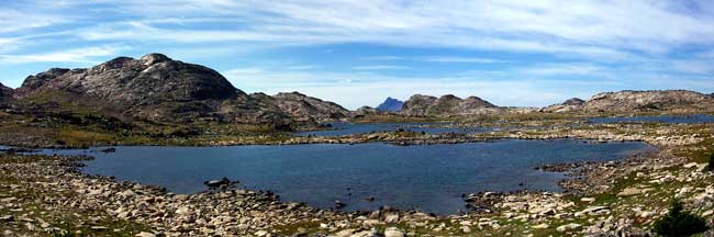
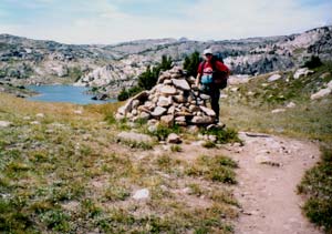 was a large rock cairn marking the spot. It also marked the boundary between
the Custer and Gallatin National Forests and also the divide between the
East Rosebud Creek and the Clarks Fork of the Yellowstone River drainages.
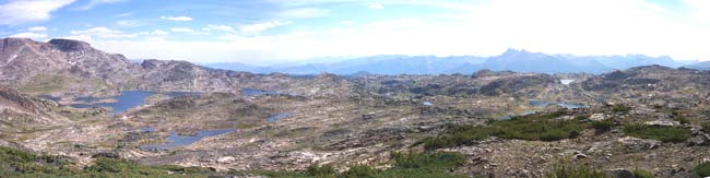
From this high vantage point we had a great view westward of Windy and
Sodalite Lakes. (Windy Lake is also called Fizzle Lake on some maps).
We were also hoping to see Granite Peak, the highest point in Montana,
located about 7 miles northward. Unfortunately there was an intermediate
ridge in our way. Diane decided we needed to leave the trail and start
hiking cross-country to that next ridge hoping for a view of Granite Peak.
Unfortunately when we got there, there was still a second ridge in our
way. Diane had to see Granite Peak. So of course we set off to climb over
that second ridge. When we got to the top of the second ridge there was
still a third ridge in our way. Being an engineer, I could see a pattern
starting to emerge. Fortunately, I was able to convince Diane that there
was probably several more ridges that were between us and a view of Granite
Peak, that it was getting late in the afternoon, that we still had to
find our way back to Fossil Lake and the trail, and that we still had
a distance to cover to get back to camp before dark. On our way back to
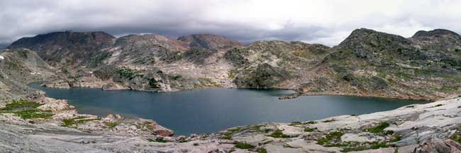
Fossil Lake we got a nice panoramic view of the lake from the top of one
of the ridges to the north of the lake. Then it was a somewhat relaxing
hike downhill back to camp.
was a large rock cairn marking the spot. It also marked the boundary between
the Custer and Gallatin National Forests and also the divide between the
East Rosebud Creek and the Clarks Fork of the Yellowstone River drainages.
From this high vantage point we had a great view westward of Windy and
Sodalite Lakes. (Windy Lake is also called Fizzle Lake on some maps).
We were also hoping to see Granite Peak, the highest point in Montana,
located about 7 miles northward. Unfortunately there was an intermediate
ridge in our way. Diane decided we needed to leave the trail and start
hiking cross-country to that next ridge hoping for a view of Granite Peak.
Unfortunately when we got there, there was still a second ridge in our
way. Diane had to see Granite Peak. So of course we set off to climb over
that second ridge. When we got to the top of the second ridge there was
still a third ridge in our way. Being an engineer, I could see a pattern
starting to emerge. Fortunately, I was able to convince Diane that there
was probably several more ridges that were between us and a view of Granite
Peak, that it was getting late in the afternoon, that we still had to
find our way back to Fossil Lake and the trail, and that we still had
a distance to cover to get back to camp before dark. On our way back to
Fossil Lake we got a nice panoramic view of the lake from the top of one
of the ridges to the north of the lake. Then it was a somewhat relaxing
hike downhill back to camp.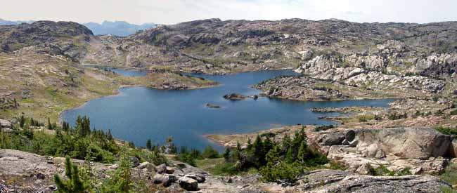
 The
next day didn't dawn as nice and clear as yesterday. It was more overcast
and it looked like we were in for rain sometime that day. We again started
off up the main trail just like yesterday heading for the creek crossing.
There we left the trail and headed north up the small creek valley. The
going was fairly easy. We'd try crossing the creek every time the route
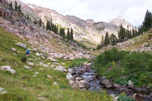
looked easier on the other side. Shortly after we turned a bend we came
across a lovely 20 ft waterfall spilling into a rocky pool. While the
waterfall was scenic, it also meant that the terrain was suddenly much
steeper in order to keep up with the creek.
The
next day didn't dawn as nice and clear as yesterday. It was more overcast
and it looked like we were in for rain sometime that day. We again started
off up the main trail just like yesterday heading for the creek crossing.
There we left the trail and headed north up the small creek valley. The
going was fairly easy. We'd try crossing the creek every time the route
looked easier on the other side. Shortly after we turned a bend we came
across a lovely 20 ft waterfall spilling into a rocky pool. While the
waterfall was scenic, it also meant that the terrain was suddenly much
steeper in order to keep up with the creek.