The
Travelogues of Diane and Dave
|
The
Travelogues of Diane and Dave
|
|||
|
|
 |
||||||
|
|
|
||||||
|
|
| |||||
|
|
|
|
Saturday, 3/14/09 To get to Cat Island, we used Southwest Airlines to fly to Ft Lauderdale (FLL) and then Lynx Air to The Bight airport (TBI). Southwest couldn't get us to FLL early enough for the Lynx departure so we flew to FLL the evening before and stayed one night at the Rodeway Inn in Fort Lauderdale. It was the cheapest place we could find near the airport with a free airport shuttle service.
By this time we were getting hungry and looking for some food. We hadn't passed any restaurants on our drive up to Pigeon Creek so we decided to continue driving north to see what we could find. We got all the way to the northern end of the island near Orange Creek without finding an open restaurant. Somewhat discouraged we turned around and headed back home. Along the way we passed by a group of "cruisers" eating out of styrofoam boxes sitting at a picnic table next to a house. We stopped and asked them where they got the food. It turned out the house next door was a restaurant! The owner "Yaddie" [sp] said she had a pork dinner and a fish dinner left that she could serve us. We accepted both and after a short wait we were sitting down with the cruisers enjoying our dinners. It's a good thing those cruisers were sitting there or we'd never have known it was a restaurant and we would have missed out on some good, inexpensive food.
Today we walked along our beach to end of Alligator Point. We started out walking along the sandy beach. After about 2 miles the sandy beach ended and turned into rocky shoreline. The rough rocks made the going much slower so we headed inland and picked up the dirt road that ran out to the end of the point. The road was in fairly decent shape except for 1 or 2 short sections of deep soft sand that would have easily bogged down a vehicle without 4-wheel drive and high ground clearance. At the end of the point is the entrance to Aligator Creek. There we found a nice Casuarina tree to sit under while we ate our lunch. Then we swam off the small beach and snorkeled around the rocks. The snorkeling experience was not very exciting, not a lot to see, fish-wise, and the water was a little choppy making for poor water clarity.
For simplicity and ease, we walked back to our house using the road. That way we could check out the backside of the other houses we had seen along the beach. Later that night we watched the NASA space shuttle launch from the house deck. We could make out the fiery orange streak on the far northern horizon followed by the strangest big white glowing cloud in the sky. The cloud was so strange because it was about 8pm and after dark. The cloud must have been so high up in the atmosphere from the shuttle that the sun hadn't set yet at that altitude. Mon, 3/16/09
After leaving The Hermitage, we continued our journey south. At the end of the island is a traffic circle. You can go to the left or right. We took the right turn (eastward) and after enough turns the paved road ends and turns dirt. It continues a bit further and you find yourself at Hawk's Nest Resort (www.hawks-nest.com). We had lunch at their restaurant after which we walked around the property a bit. The place looked deserted, the beach looked real small. Just down the road from the resort is a small airport and beyond that is a small marina. The marina had a dive shop and several fishing charter operations. Leaving Hawk's Nest, we returned to the traffic circle and took the westward road. It too has several turns till the pavement ends and the dirt starts. At the end of the road was Greenwood Beach Resort (www.greenwoodbeachresort.com). This place looked a little livelier with a few people lounging on the beach, . . . . and what a nice beach they had! It was about 8 miles long. There were several coral heads off the beach for snorkeling and they had a dive shop there also. By this time we were hot and thirsty and asked the owners if they had any bottled water for sale. The owner returns with a pitcher of ice water and 3 glasses and sits down with us at a table on the patio and starts talking with us. What a friendly guy! We learned a lot about the island and our hosts back at Pigeon Cay Beach Club. After thanking our host we left and returned to our Boathouse. Along the way back home, we found the remains of the old intra-island railway that had been used to transport crops to the western coast for shipping back to the US. It eventually became unprofitable and the shipments and the railway died out. Tues, 3/17/09 After yesterday, I was tired of driving, so we stayed local. We took 2 kayaks from the resort beach and paddled up to the end of Alligator Point, paddling along the same beach we had walked along a few days ago. Again we stopped at the small beach at the end and ate a snack under our now favorite Casuarina tree.
Eventually the main branch widened out into a large shallow pool. We could see our house about 200 yards ahead, but the water was too shallow to paddle. So we had to get out and walk thru the soft muck dragging the floating empty kayaks behind us. Eventually, the last 30 yards or so the water totally disappeared and we had to drag the kayaks over the soft muck. It wasn't too bad; at least the muck didn't stink! That evening we had a catered supper over at the Pigeon Cay Beach Club. The food was great, the ambience was great (sitting at a table on the beach watching the sun set), but the price was a bit steep (~$40 pp).
After all of yesterday's paddling and kayak dragging, I was ready to drive again. This time we headed to the north end of the island. Along the way north, we stopped off at Miss. Ella Larimore's Straw Shoppe. At about 81 yrs old, she still weaves intricate baskets, bags, and hats. Diane found a nice straw sun hat. We regret that we didn't have Miss Larimore pose for a photo with Diane and the hat. Further north from Miss Larimore's, we found a reasonable looking road (Dickies Rd.) leading east towards the Atlantic side of the island. We followed the road all the way to the coast. The Atlantic beach area was very disappointing. It was very rocky with no decent beach area. On the way back to the western side, we passed a small sign that read "Cave" with an arrow pointing into the woods. Curious, we parked and followed the path about 20 yards to a cave. It was a decent sized cave that had been used by early settlers to escape from bad weather and marauding pirates. About 10 feet into the cave they had built a stone wall with a small window and door. The settlers could go behind the wall and close the door for protection from the pirates.
It was another day of kayaking again. This time we started from the house and dragged the kayaks thru the mud until the water got deep enough. (When the tide was high, the water would come up to the beached kayaks, but it seemed like it was always high tide at 6am and 6pm. Not the best times to go kayaking.) We were hoping to encounter the sea turtles again and possibly snorkel with them. Unfortunately we didn't encounter many turtles on this trip. Plus there was never a good shoreline to pull the kayaks up on. When we finally found a beach area, there were no more turtles. We stopped anyway and we snorkeled a bit along the mangrove shoreline checking out the tiny fish living amongst the mangrove roots. We left and continued out the mouth of the creek and followed the beach back to the Pigeon Cay Beach Club where we returned the kayaks.
Today was our last day and we wanted it to be relaxing. We had previously walked along the beach out to the end of Alligator Point, so we figured that this time we would walk the beach in the other direction. Past the Pigeon Cay Beach Club we ran into a young couple from one of
the Carolinas, or was it Tennessee, or was it Kentucky? Any way, we enjoyed the small beach and snorkeled amongst the rocks off the shore. Unfortunately, the fish viewing was not the best.
Today was our last day. After packing up and paying our last bill with our hosts at the Pigeon Cay Beach Club, we drove back to the airport and dropped off our luggage. Then we returned the rental car to the gas station and then they shuttled us back to the airport. Our flights back home to Baltimore via Fort Lauderdale were fortunately uneventful.
|
|||||||
|
|
|
||||||
|
|
| |||||
|
|
|
|
|
|
last revised
:
August 19, 2009
|
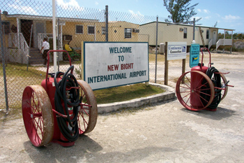 The
airport at The Bight is your typical small Bahamas airport with one terminal
building that serves as the departure and arrival gates, customs, and
immigration office. We had previously arranged for a "jeep"style
rental car thru the New Bight Service station. We were expecting the usual
beat-up rattle-trap rental we get in Eleuthera but were very pleasantly
surprised by the nearly new Mazda Tribute we were given! After some minimal
paperwork and exchanging of money we were on our way. The car rental folks
recommended a grocery store just up the road for our initial stocking
up of food stuffs. Then it was a pleasant 45 minute drive up the island
to Pigeon Cay and our rental property called "The Boathouse"
(www.catislandboathouse.com). We got settled in, stopped off at the local
property managers at the nearby Pigeon Cay Beach Club(www.pigeoncay-bahamas.com)
The
airport at The Bight is your typical small Bahamas airport with one terminal
building that serves as the departure and arrival gates, customs, and
immigration office. We had previously arranged for a "jeep"style
rental car thru the New Bight Service station. We were expecting the usual
beat-up rattle-trap rental we get in Eleuthera but were very pleasantly
surprised by the nearly new Mazda Tribute we were given! After some minimal
paperwork and exchanging of money we were on our way. The car rental folks
recommended a grocery store just up the road for our initial stocking
up of food stuffs. Then it was a pleasant 45 minute drive up the island
to Pigeon Cay and our rental property called "The Boathouse"
(www.catislandboathouse.com). We got settled in, stopped off at the local
property managers at the nearby Pigeon Cay Beach Club(www.pigeoncay-bahamas.com)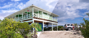 to let them know we had arrived and then briefly checked out the beach.
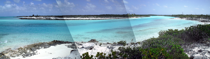
 Today
we hopped into our rental car and headed south to check out the bottom
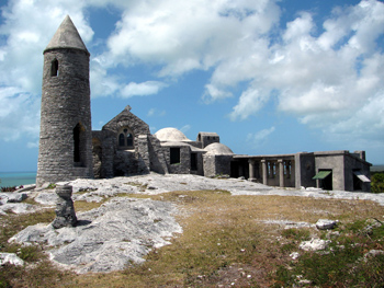
end of the island. Just south of New Bight is "The Hermitage",
a miniature monastery built on Mt. Alvernia in the 1940s by Father Jerome,
an architect and Jesuit missionary.Mt. Alvernia is the highest point in
the Bahamas at 206 feet above sea level. It's a short steep walk up to
the top of the hill and the monastery. Along the way are small stone tablets
with sayings. The monastery consisted of a very small one-man chapel,
a kitchen, a bedroom, and a bell tower. The accommodations looked very
austere. From the backside of the monastery you can follow a path off
to the left to the cave where he first lived while building the monastery.
Today
we hopped into our rental car and headed south to check out the bottom
end of the island. Just south of New Bight is "The Hermitage",
a miniature monastery built on Mt. Alvernia in the 1940s by Father Jerome,
an architect and Jesuit missionary.Mt. Alvernia is the highest point in
the Bahamas at 206 feet above sea level. It's a short steep walk up to
the top of the hill and the monastery. Along the way are small stone tablets
with sayings. The monastery consisted of a very small one-man chapel,
a kitchen, a bedroom, and a bell tower. The accommodations looked very
austere. From the backside of the monastery you can follow a path off
to the left to the cave where he first lived while building the monastery.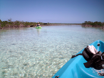 After
our lunch, we continued kayaking up the creek. It was like a maze of mangrove
swamps off to either side, but we continued to follow the main branch
which was rather wide and deep. While kayaking we started noticing dark
shapes moving under water. It was like watching UFO's darting about in
the sky only this time the dark shapes were darting about under water.
They'd always stay ahead of us. Eventually several came to the surface
to breathe and we could see that they were sea turtles! Their shells were
about 1.5 to 2 feet in diameter. We enjoyed watching them darting about
ahead of us and coming to the surface to breathe.
After
our lunch, we continued kayaking up the creek. It was like a maze of mangrove
swamps off to either side, but we continued to follow the main branch
which was rather wide and deep. While kayaking we started noticing dark
shapes moving under water. It was like watching UFO's darting about in
the sky only this time the dark shapes were darting about under water.
They'd always stay ahead of us. Eventually several came to the surface
to breathe and we could see that they were sea turtles! Their shells were
about 1.5 to 2 feet in diameter. We enjoyed watching them darting about
ahead of us and coming to the surface to breathe.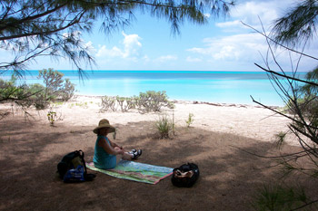 Leaving
Dickies Rd. we continued north past Orange Creek. There's a nice grocery
store there with rooms for rent upstairs (www.the-bahamas-hotels.com/orangecreekinn).
Shortly past the Orange Creek grocery store the road turns to dirt and
enters a residential area. Some of the roads are private and have signs
saying "Private - Keep Out", so we stayed away from those. The
people living there seemed somewhat "xenophobic". One neighbor
who was outside collecting her mail told us about Port Royal beach nearby,
partly we feel in an attempt to get us out of the neighborhood even though
we were on a public road. Nevertheless, it was a great beach! We had the
whole place to ourselves. Nothing worth snorkeling though.
Leaving
Dickies Rd. we continued north past Orange Creek. There's a nice grocery
store there with rooms for rent upstairs (www.the-bahamas-hotels.com/orangecreekinn).
Shortly past the Orange Creek grocery store the road turns to dirt and
enters a residential area. Some of the roads are private and have signs
saying "Private - Keep Out", so we stayed away from those. The
people living there seemed somewhat "xenophobic". One neighbor
who was outside collecting her mail told us about Port Royal beach nearby,
partly we feel in an attempt to get us out of the neighborhood even though
we were on a public road. Nevertheless, it was a great beach! We had the
whole place to ourselves. Nothing worth snorkeling though.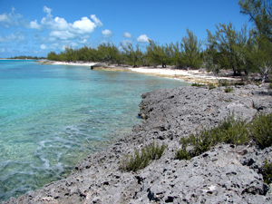 Anyway,
they were staying at Mike's Beach House ( www.pigeoncay-bahamas.com/index_files/Page426.htm
, scroll down the page).They were walking the beach in the other direction.
After a lengthy chat, we continued in our southerly direction. The private
homes stopped and eventually the sandy beach did also. The shoreline turned
into a low rocky cliff. We stopped at the last sandy strip of beach. Behind
us in the woods were the ruins of an old church and an old cemetery. It
seems like in the islands they always put cemeteries on prime waterfront
land. Maybe the islanders figure that when they die, they can continue
to enjoy a beautiful ocean view for eternity.
Anyway,
they were staying at Mike's Beach House ( www.pigeoncay-bahamas.com/index_files/Page426.htm
, scroll down the page).They were walking the beach in the other direction.
After a lengthy chat, we continued in our southerly direction. The private
homes stopped and eventually the sandy beach did also. The shoreline turned
into a low rocky cliff. We stopped at the last sandy strip of beach. Behind
us in the woods were the ruins of an old church and an old cemetery. It
seems like in the islands they always put cemeteries on prime waterfront
land. Maybe the islanders figure that when they die, they can continue
to enjoy a beautiful ocean view for eternity.