The
Travelogues of Diane and Dave
|
The
Travelogues of Diane and Dave
|
|||
|
|
 |
|
|
|
|
|
|
||||
|
|
^you are here^
|
|||||||
|
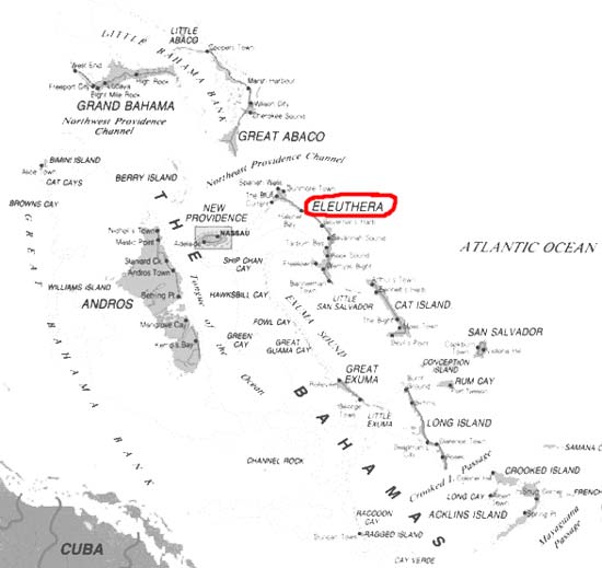
Map of Bahamas
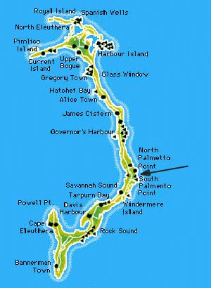
Map of Eleuthera This is a general map of Eleuthera. The arrow points to the Palmetto Point area where the rental house "le Sable Rose is located.
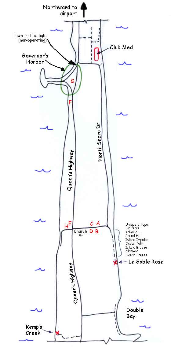
Map of Palmetto Point area around Le Sable Rose Here's a map of the area around North Palmetto and the house (le Sable Rose). It's approximately to scale since I traced it. At the bottom of the map is a key to the red letters.
Map Key
Some Mileages
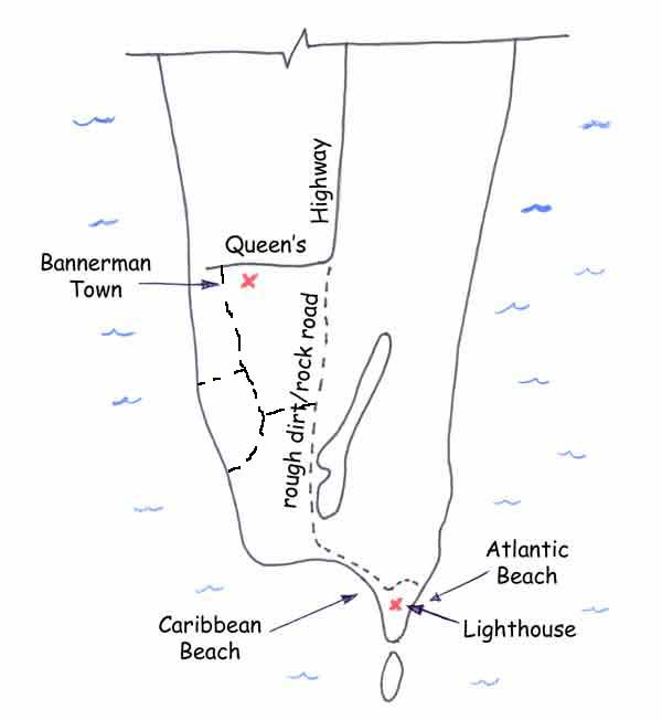
Directions to Club Med beach: I found at least 3 ways to get there. 1) From le Sable Rose you can drive into Palmetto Point. When you get to the edge of town at the intersection with Church St. by the large tree, go straight onto North Shore Dr. instead of turning left onto Church St. At first North Shore Dr. is a very small narrow road but as you leave the town area it opens up. The road takes you right past the Club Med entrance gate. From the entrance gate you can back track along North Shore Dr. to a dirt road that will take you right out onto the beach. Or you can pass the entrance gate and take the first right onto a poor dirt road that skirts the Club Med property line. Watch for a small rocky rough jeep trail going down to the beach on the right. Park at the start of this road or if you have a jeep, drive down to the beach. You'll soon see the dilapidated Club Med buildings on your right. Ahead of you is gorgeous beach. 2) From Queen's Highway, head north out of Governor's Harbor. About 100 yards past the large blue sign saying "Welcome to Governor's Harbor" (you'll have to look back to see the sign) there's a half paved half rock road turning right off to the Atlantic. Take that rough road about 1/2 mile and when it ends turn right. In a short distance is a small rocky rough jeep trail going down to the left. Park at the start of this road or if you have a jeep, drive down to the beach. 3) The third way is from the town of Governor's Harbor. Somewhere near the Shell gas station at the north end of town, by the traffic light and near the Duck Inn, you turn towards the Atlantic and head uphill for the Batelco tower. Somehow you get onto the beginning of North Shore Dr. and can then head for the Club Med front gate. From there you can follow the directions in option 1) above. I'm sorry I can't describe the route better. I'm came out this way but couldn't figure the route out in reverse since there were some one-way roads involved. Directions to Kemp's Creek: Starting at the intersection of Queen's Highway and Church St. in Palmetto Point, head south along Queen's Highway. After about 3.5 miles you pass a very dilapidated chalet off on your right. At 4.1 miles turn right onto a dirt road and follow it for about a mile to the end. The dirt road is also the third dirt road after passing the ruined chalet. Directions to Double Bay: Starting at the intersection of Queen's Highway and Church St. in Palmetto Point, head south along Queen's Highway. Off on the left you'll come to a paved road with two concrete/stone pillars on either side of the entrance. Drive down that road till it ends. Turn right, the road is now rough broken pavement. Follow it past all the large fancy homes on your left till the road peters out. It's a short walk to the nice secluded beach area. Map of Lighthouse Point area at south end of Eleuthera It's a long drive down to Lighthouse Beach, but very much worth it. You'll kick yourself in the pants afterwards if you don't go. Just follow the Queen's Highway south towards Bannerman Town. Just before entering Bannerman Town, the road turns right. Just follow the small dirt road that continues straight into the woods till it ends at a beautiful beach.
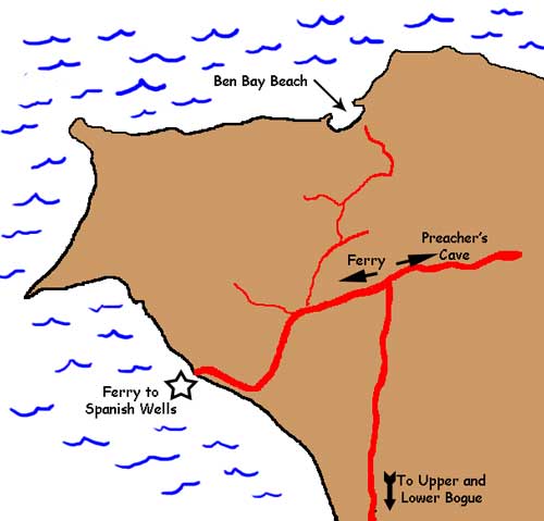
Directions to Ben Bay Beach: Starting at the Glass Window Bridge, keep heading north along the Queen's Highway all th way up into northwestern Eleuthera. Continue on like you're heading for the Spanish Wells ferry. Before the ferry, the road comes to a "T" intersection with Preacher's Cave to the right and the Ferry to the left. Turn left towards the ferry. Take the next right hand turn. (You can also drive to the ferry, then turn around and drive back and take the second left hand turn, That's what we ended up doing). Then follow the route shown below, alternating taking left and right turns. Once off the main highway, you're driving thru a farming area of privately owned orchards and fields. No sampling the fruits! These back roads are small dirt roads but were in good condition.
Directions to other Eleuthera beaches: In order to find the rest of the beaches we went to plus lots more beaches, I'd very highly recommend getting the book "The Elusive Beaches of Eleuthera". Those authors provide detailed driving directions and GPS coordinates for getting to the beaches. They also provide a rating system comparing the beach accessibility, swimming conditions, shelling potential, seclusion, and snorkeling quality. The book is available thru their own website at http://www.elusivebeaches.com.
|
|||||||||||||||||||||||||||||||||||||||||||||||||||||||
|
|
|
||||||||||||||||||||||||||||||||||||||||||||||||||||||
|
|
|
||||||||||||||||||||||||||||||||||||||||||||||||||||||
|
|
|
last revised
:
June 13, 2006
|